The United States Geological Survey recorded a Magnitude 4.6 Earthquake at a depth of 18 km, slightly off the coast of Limón Province in northeast Costa Rica slightly before 1.30 am (slightly before 7.30 am GMT) on Sunday 21 June 2015. This was not a large quake, and had little potential to be dangerous; no damage or casualties have been reported, but the quake was felt from Puerto Limon on the coast as far inland as San Jose in the center of the country.
The approximate location of the 21 June 2015 Costa Rica Earthquake. Google Maps.
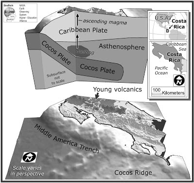
Costa Rica lies on the southern margin of the Caribbean Plate; to the south of the country the Cocos Plate, which underlies part of the eastern Pacific Ocean) is being subducted under the Middle American Trench, passing under Central America as it sinks into the Earth's interior. This is not a smooth process, and the plates often stick together until the pressure builds up enough to force them to shift suddenly, causing Earthquakes. As the Cocos Plate sinks deeper if is partially melted by the friction and the heat of the Earth's interior. Some of the melted material then rises up through the overlying Caribbean Plate, fueling the volcanoes of Central America.
Diagram showing the passage of the Cocos Plate beneath Costa Rica (not to scale). Carleton College.
Witness accounts of Earthquakes can help geologists to understand these events, and the structures that cause them. The international non-profit organization Earthquake Report is interested in hearing from people who may have felt this event; if you felt this quake then you can report it to Earthquake Report here.
See also...
The Observatorio Vulcanologico y Sismologico de Costa Rica-Universidad Nacional in Costa Rica reported a large phreatic eruption on Mount Poás, a volcano in the central part of the country, slightly after noon local time (slightly after 6.00 pm GMT) on Tuesday 25 February 2014. Phreatic eruptions occur when...
The United States Geological Survey recorded a Magnitude 6.0 Earthquake at a depth of 18 km, off the coast of northwest Costa Rica slightly before...
At about 4.50 am local time (10.50 am GMT) seismic activity (Earthquakes) began around Mount Turrialba, a 3340 m stratovolcano (cone-shaped volcano) in Cartago Province, Costa Rica, which then began to emit stream and CO₂ according to Volcanological and Seismological Observatory of Costa Rica (Oviscori)...
Follow Sciency Thoughts on Facebook.


